
- February 15, 2021
- UNSW
- Blog
- 1 Comment


Australia’s Food Bowl - The Murray-Darling Basin
Australia’s Food Bowl – The Murray-Darling Basin
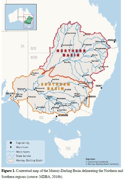
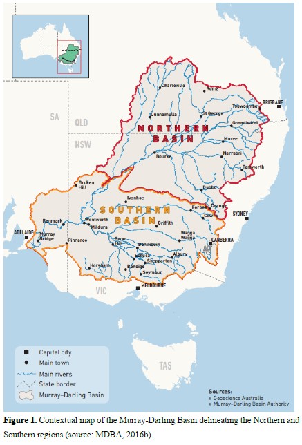
The Murray-Darling Basin (MBD) is a river system that covers 14% of the land in Australia. 70% of Australia’s agricultural water use comes from the MDB and it provides one third of Australia’s food supply. Which is how the basin earned its nickname Australia’s Food Bowl. The MDB extends across four states and one territory, covering 75% of NSW and over half of Victoria. The Murray River actually forms the border between these two states. To put it in context, the MDB is larger than the size of Germany and France combined. And, more than two million people call the Basin home.
The Murray-Darling Basin is unique
The MDB has 15 bioregions, 23 river valleys and over 30,000 wetlands. More than 100 of these wetlands has national significance and internationally, the RAMSAR convention recognises 16. The Basin is home to 45 native fish species, 35 endangered bird species, and 16 endangered mammal species. The basin is also country to more than 40 Indigenous nations. There are more than 10,000 known Aboriginal sites, including the World Heritage listed sites at Willandra Lakes.
Murray-Darling Basin Management
In businesses, we would say that management of the MBD is challenging. It is much of a VUCA case (volatile, uncertain, complex and ambiguous). Balancing the competing interests and priorities between land productivity and conservation of natural resources makes water resource management complex and often divisive. The MDB is the most regulated river system in Australia. It has a system of locks, weirs, and dams used to control the release of water for different purposes. The regulations are heavier in the Southern Basin than the Northern Basin, there are major storages in many rivers, including the Murray and Goulburn.
Agriculture in the Murray-Darling Basin: Australia’s Food Bowl
The MDB is Australia’s main region for irrigated agriculture. 70% of agricultural water use and almost 50% of irrigated agricultural production value came from the MDB in 2017-18. Irrigated agriculture (3% of the land) accounted for 36% of the value of agricultural production in the Basin in 2017-18. Cotton, fruit and nuts, dairy, grapes and vegetables generated the greatest value. Cotton is predominantly grown in the Northern Basin. But, most other irrigated crops are concentrated in the major irrigation areas of the Southern Basin. These areas include Murrumbidgee Irrigation, Coleambally Irrigation, Murray Irrigation and Goulburn–Murray Water. Irrigated agriculture tends to be more intensive and profitable than dryland production. Other regions of the world characterised by highly variable climatic conditions and prolonged droughts also follow this trend.
Irrigated agriculture, combined with other environmental issues such as increased erosion and salinity, blue-green algal blooms, reduced water quality and invasive species, place significant pressure on basin ecosystems. Water irrigation competes with environmental flows to manage water quality and sustain important elements of biodiversity in the MDB. Such pressures may increase in the future, with the median 2030 climate change predictions from CSIRO. The predications indicate a decline in surface water availability across the Basin by 12%. 67% of the overall reduction will be concentrated in the Southern Basin, in the Goulburn-Broken, Ovens, Murray, and Murrumbidgee regions. Further, CSIRO predicts drought conditions will become increasingly common in the MDB as the climate changes. There are other risks to future water availability in the region including growing urban water demand, changing land use, and vigorous forest regrowth after bushfire.
COALA and the Murray-Darling Basin
Earth Observation products and services can help address the aforementioned challenges. And for this reason, a consortium of Australian and European universities, SMEs, and business users that believe in the potential of EO got together and developed the concept of COALA (which stands for Copernicus Applications and services for Low impact agriculture in Australia). The 3-year project was funded by the Horizon2020 program of the European Union. COALA will develop EO-based services using the Copernicus Sentinel satellites coupled with data from in-situ and airborne sensors —for validation and calibration of the products. We are transferring technology that has proven successful in support of sustainable water and nutrient management in European farms (Spain and Italy) and adapting it to the conditions of Australia (e.g. our paddocks are several times larger than the typical European size, our soils and climate regimes are different).
Why the MDB, and Australia?
Aussie farmers are known around the world for their advanced level of adoption of new technologies (sensors, computers, electronic controls, etc). Australia has a highly skilled and innovative farming community. The size of the Australian paddocks in the MDB, and its importance as Australia’s Food Bowl, makes it ideal for the work with satellites as the Sentinel from Copernicus detects an object as small as 10×10 meters. There is also an urgent need to match agricultural productivity with environmental concerns (as described above).
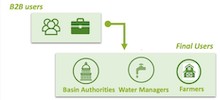
COALA will build on existing services of the business users that are part of the consortia. We will use state of the art Copernicus Data and Information Access Services (called DIAS) to ensure near real time distribution of products generated from satellite, for business users, farmers and water management authorities to make decisions with the best possible information.
As a farmer, how do i get access to my data?