Coala Project > Project > Technology

Technology for COALA

COALA will develop Copernicus-based information service for irrigation and nutrient management, built on the consolidated past experiences of the proposed partnership within the context of recent EU projects such as FATIMA (http://fatima-h2020.eu/) and DIANA (https://diana-h2020.eu). 

COALA aims at integrating these operational services into existing Australian platforms by adapting them, with technological improvements, to the environmental and agronomical conditions of Australia.

Several sources of data will be exploited: Satellite data, UAV, airborne data, into field sensor data, etc

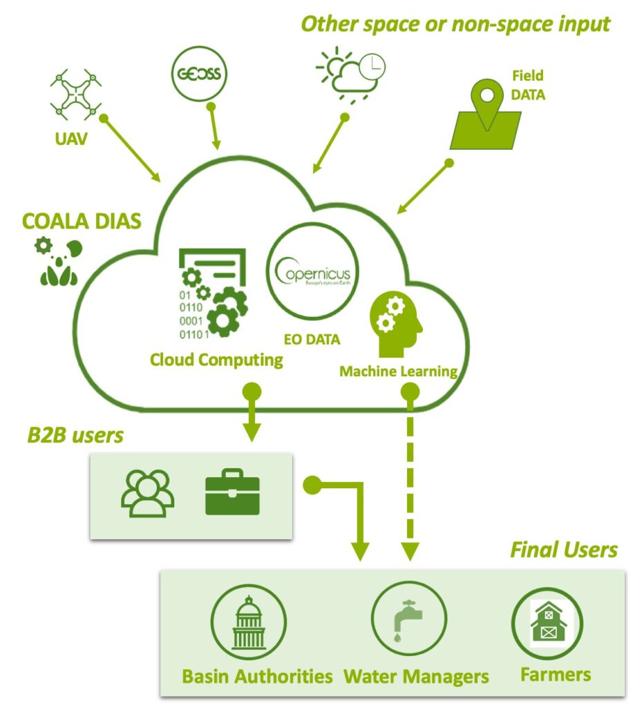
The service will be delivered by taking advantage of the possibilities offered by the new DIAS of Copernicus in which novel algorithms will be deployed using the state of art technologies (Machine learning, Cloud computing, ecc).

The collaboration between EU and Australian research teams will bring into COALA advanced algorithms for detecting crop water and nutritional status from Sentinel observations, thus allowing the transferability of the services developed in EU within the Australian context. The improved services will be integrated into the platforms already used in Australia for supporting irrigation, such as FarmConnect® Software by Rubicon Water  and software for yield forecasting and nutrient management such as YieldProphet® by Birchip Cropping Group . This integration brings in a new business model for the market exploitation of such Copernicus-based services 

Irrigation Management at district scale

COALA develops and implements Earth Observation technologies in support to water management by integrating in-situ and field monitoring devices.

The combination of Earth Observation data, agricultural and hydrology sciences, new communication technologies, field measurement instrumentation allow the development of innovative products for a growing market that needs new solutions to face current and upcoming problems related to sustainable natural resources management, natural risk mitigation and decision making processes.

The service aim to:

  • Compare crop water requirements Vs irrigation water uptake in space and Time
  • Evaluate of irrigation efficiency
  • Optimise water Allocation

Irrigation Management at farm scale

COALA develops and implements Earth Observation technologies integrated with in-situ and field monitoring devices to support water management of the farm.

The combination of Earth Observation data, agricultural and hydrology modelling, new communication technologies, field measurement instrumentation allow the development of innovative service for a growing market that needs new solutions to face current and upcoming problems related to sustainable water resources management, natural risk mitigation and decision-making processes.

The service aim to:

  • Guide irrigation delivery
  • Provide time series map of Crop Water Requirement with a forecast up to 5 days
  • Integrate the information by existing soil moisture probe
  • Monitor Crop development in real-time

Nutrient Management at farm scale and yield monitoring

COALA develops and implements Earth Observation  technologies integrated with in situ and field monitoring devices to support nutrient management of the farm.

The combination of Earth Observation data, agricultural knowledge, nitrogen balance modelling, precision agriculture, variable rate technology, new communication technologies allows the development of innovation service for a growing market that needs new solutions to make a more efficient and competitive agriculture in a sustainable environment.

we will need to be specifci of copernicus sentinel here, as there are many products developed using EO (Landsat, SPOT, Planet Lab, etc).

The service aim to:

  • Classify by categories the extension of your plots within a zone in a paddock?
  • Know the yield of each zone
  • Identify areas that require special attention
  • Determine appropriate sampling points (soil, quality, maturity, yield)
  • Decide the most appropriate fertilizer and seed rate of each zone
  • Create application maps that are compatible with your variable rate spreader suggest using the word paddock that is the australian for plot.
  • Enable differential harvest by quality zones
  • Quantify damages caused by any crop incident
  • Know the actual water consumption in each zone
  • Quantify the savings obtained through variable rate applications


Dont'miss any update on

Coala and Earth observation

in Australia

Subscribe now to Coala Project newsletter!!!

    By subscribing you agree to receive our promotional marketing materials and agree with out Privacy Policy. You may unsubscribe at any time.