
- September 8, 2021
- UNSW
- Blog
- No Comments


Satellites Detect Environmental Change
Satellites Detect Environmental Change
Every year in August Australian National ‘Science Week’ takes place. During National Science Week hundreds of events take place around the country. These events help engage people with science and give scientists a chance to showcase their research. One of our goals in the COALA Project is to support and focus on legacy, which so far we’ve been accomplishing through work developing educational resources for high school students. For National Science Week we developed two virtual seminars with Professor Graciela Metternicht from UNSW School of Biological, Earth and Environmental Science over two days. Both were broadly on the same topic of how satellites detect environmental change. But, one of the seminars was directed more for high school purposes, while the other was for general audiences.
What were the talks about?
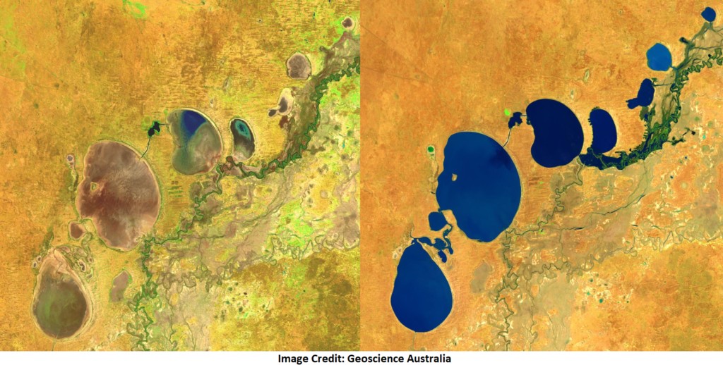
Increasingly farmers, meteorologists and climate sciences are turning to satellites to learn more about Earth, using a technique called remote sensing. We presented a case study of how important remote sensing can be, using Menindee lakes as an example. Menindee lakes area a good case study to show how satellites detect environmental change. Earth Observation can help to understand changes in landscape dynamics and to rapidly monitor the impact of those changes. Persistent drought left them practically desiccated since 2016 (the left satellite image shows how the area looked like in mid-2019). A million fish died in ‘distressing’ algal bloom at Menindee lakes in early 2019; the extreme summer conditions of 2019 could have intensified a normal phenomenon, that killed the fish.
Images from satellites of the NASA and the European Space Agency can tell the story, showing how the system of lakes was bursting full of water in 2016, and then experienced 5 years of constant decrease of fresh water, until the summer of 2020-21, when from December through February many parts of New South Wales experienced the heaviest rainfall and worst flooding in six decades. A lot of those floodwaters slowly made their way through the Darling-Baaka River system in northern New South Wales and reached the Menindee Lakes, that is once again brimming with life.
